ShopDreamUp AI ArtDreamUp
Deviation Actions


Suggested Deviants


Suggested Collections


![[AGGT] Division of Hungary (1900)](https://images-wixmp-ed30a86b8c4ca887773594c2.wixmp.com/f/1164ffd5-7a08-466e-bb07-0e8165e71bd1/ddljfn5-dd452bc2-a9d1-4ddd-a32f-df1c2d07ca62.png/v1/crop/w_184,h_184,x_10,y_0,scl_0.10556511761331,q_70,strp/_aggt__division_of_hungary__1900__by_altmaps_ddljfn5-92s-2x.jpg?token=eyJ0eXAiOiJKV1QiLCJhbGciOiJIUzI1NiJ9.eyJzdWIiOiJ1cm46YXBwOjdlMGQxODg5ODIyNjQzNzNhNWYwZDQxNWVhMGQyNmUwIiwiaXNzIjoidXJuOmFwcDo3ZTBkMTg4OTgyMjY0MzczYTVmMGQ0MTVlYTBkMjZlMCIsIm9iaiI6W1t7ImhlaWdodCI6Ijw9MTc0MyIsInBhdGgiOiJcL2ZcLzExNjRmZmQ1LTdhMDgtNDY2ZS1iYjA3LTBlODE2NWU3MWJkMVwvZGRsamZuNS1kZDQ1MmJjMi1hOWQxLTRkZGQtYTMyZi1kZjFjMmQwN2NhNjIucG5nIiwid2lkdGgiOiI8PTIxMzUifV1dLCJhdWQiOlsidXJuOnNlcnZpY2U6aW1hZ2Uub3BlcmF0aW9ucyJdfQ.rZr8KBZMWLdYiCAHm1HOcRZvYm63UDxLKpAf3uuBqw8)
![[AGGT] Division of Hungary (1900)](https://images-wixmp-ed30a86b8c4ca887773594c2.wixmp.com/f/1164ffd5-7a08-466e-bb07-0e8165e71bd1/ddljfn5-dd452bc2-a9d1-4ddd-a32f-df1c2d07ca62.png/v1/crop/w_92,h_92,x_5,y_0,scl_0.052782558806655,q_70,strp/_aggt__division_of_hungary__1900__by_altmaps_ddljfn5-92s.jpg?token=eyJ0eXAiOiJKV1QiLCJhbGciOiJIUzI1NiJ9.eyJzdWIiOiJ1cm46YXBwOjdlMGQxODg5ODIyNjQzNzNhNWYwZDQxNWVhMGQyNmUwIiwiaXNzIjoidXJuOmFwcDo3ZTBkMTg4OTgyMjY0MzczYTVmMGQ0MTVlYTBkMjZlMCIsIm9iaiI6W1t7ImhlaWdodCI6Ijw9MTc0MyIsInBhdGgiOiJcL2ZcLzExNjRmZmQ1LTdhMDgtNDY2ZS1iYjA3LTBlODE2NWU3MWJkMVwvZGRsamZuNS1kZDQ1MmJjMi1hOWQxLTRkZGQtYTMyZi1kZjFjMmQwN2NhNjIucG5nIiwid2lkdGgiOiI8PTIxMzUifV1dLCJhdWQiOlsidXJuOnNlcnZpY2U6aW1hZ2Uub3BlcmF0aW9ucyJdfQ.rZr8KBZMWLdYiCAHm1HOcRZvYm63UDxLKpAf3uuBqw8)


You Might Like…


![Serbian Empire (definitive version) [Serbian]](https://images-wixmp-ed30a86b8c4ca887773594c2.wixmp.com/f/ef6b8dd8-019a-46d2-82c7-d6552aae852b/dcqsdve-7703b63c-73bb-4838-889a-66c9646b5ad4.png/v1/crop/w_184,h_184,x_0,y_0,scl_0.078098471986418,q_70,strp/serbian_empire__definitive_version___serbian__by_drakithedude_dcqsdve-92s-2x.jpg?token=eyJ0eXAiOiJKV1QiLCJhbGciOiJIUzI1NiJ9.eyJzdWIiOiJ1cm46YXBwOjdlMGQxODg5ODIyNjQzNzNhNWYwZDQxNWVhMGQyNmUwIiwiaXNzIjoidXJuOmFwcDo3ZTBkMTg4OTgyMjY0MzczYTVmMGQ0MTVlYTBkMjZlMCIsIm9iaiI6W1t7ImhlaWdodCI6Ijw9MjM1OCIsInBhdGgiOiJcL2ZcL2VmNmI4ZGQ4LTAxOWEtNDZkMi04MmM3LWQ2NTUyYWFlODUyYlwvZGNxc2R2ZS03NzAzYjYzYy03M2JiLTQ4MzgtODg5YS02NmM5NjQ2YjVhZDQucG5nIiwid2lkdGgiOiI8PTIzNTYifV1dLCJhdWQiOlsidXJuOnNlcnZpY2U6aW1hZ2Uub3BlcmF0aW9ucyJdfQ.yhq74jZ5lSAjS5lEOKhvcqVe8WdCgxORm-DZREguf4A)
![Serbian Empire (definitive version) [Serbian]](https://images-wixmp-ed30a86b8c4ca887773594c2.wixmp.com/f/ef6b8dd8-019a-46d2-82c7-d6552aae852b/dcqsdve-7703b63c-73bb-4838-889a-66c9646b5ad4.png/v1/crop/w_92,h_92,x_0,y_0,scl_0.039049235993209,q_70,strp/serbian_empire__definitive_version___serbian__by_drakithedude_dcqsdve-92s.jpg?token=eyJ0eXAiOiJKV1QiLCJhbGciOiJIUzI1NiJ9.eyJzdWIiOiJ1cm46YXBwOjdlMGQxODg5ODIyNjQzNzNhNWYwZDQxNWVhMGQyNmUwIiwiaXNzIjoidXJuOmFwcDo3ZTBkMTg4OTgyMjY0MzczYTVmMGQ0MTVlYTBkMjZlMCIsIm9iaiI6W1t7ImhlaWdodCI6Ijw9MjM1OCIsInBhdGgiOiJcL2ZcL2VmNmI4ZGQ4LTAxOWEtNDZkMi04MmM3LWQ2NTUyYWFlODUyYlwvZGNxc2R2ZS03NzAzYjYzYy03M2JiLTQ4MzgtODg5YS02NmM5NjQ2YjVhZDQucG5nIiwid2lkdGgiOiI8PTIzNTYifV1dLCJhdWQiOlsidXJuOnNlcnZpY2U6aW1hZ2Uub3BlcmF0aW9ucyJdfQ.yhq74jZ5lSAjS5lEOKhvcqVe8WdCgxORm-DZREguf4A)

Comments17
Join the community to add your comment. Already a deviant? Log In
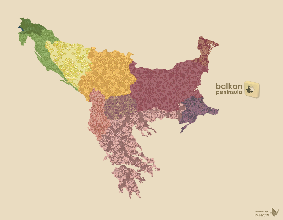
you have to make a new one  (Wink)") , there are two more states created, Montenegro and Kosovo.
, there are two more states created, Montenegro and Kosovo.